Provisional Solution C – Modelling / Deployment
An analysis of the different stages of the park’s design process [i] reveals that the initial pathway proposed, especially in the South Zone of the park, is similar to the Santa Gertrudes Park pathway system, using many of the same routes.
A further study of pathways took place in 1968 [ii], at a late stage in the process. On 10 September, 1969, it was completed.
[ii] Definitive Solution A – Modelling/Implementation
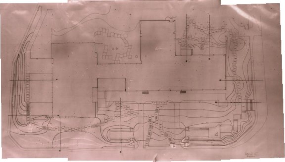
Definitive General Plan with level curves
Definitive General Plan with level curves
Topographic plan of the North east boundaries of Gulbenkian Park
Definitive General Plan I – 1969
Definitive General Plan II – 1969
- Production date: 22/08/1968
- Designers (main authors): BARRETO, António Facco Viana, TELLES, Gonçalo Pereira Ribeiro
- Contributors (co-authors): FCG – Serviço de Projectos e Obras
- Project phase: Do projeto de execução à obra (1963-1969)
- Temporal coverage: 1968
- Type of data: Image
- Extension format: 1 desenho
- Media format: jpg
- Materials: concrete, granite, rock, stone slab
- Keywords: circulation system, limit, path system, section, sketch, sketch, stairs, steps, system